Trail Walking Le Morne-Rouge - Mac Intoch - Morne Capot - Photo

Mac Intoch - Morne Capot

 Lamartiniere
Lamartiniere

User GUIDE

© OpenStreetMap contributors
Length
Length
9.4 km
Max alt
Max alt
614 m
Uphill gradient
Uphill gradient
369 m
Km-Effort
Km-Effort  
14.9 km
Min alt
Min alt
155 m
Downhill gradient
Downhill gradient
533 m
Boucle
Boucle
No
Creation date :
2019-06-05 11:07:56.734
Updated on :
2019-06-05 16:45:36.816

(1 Reviews)

Walking
Walking
4h53
Difficulty : Medium

Scan this QR Code to open this trail in the SityTrail application

FREE GPS app for hiking

Logo SityTrail SityTrail

IGN / Geographical institutes

Download SityTrail from the App Store Download SityTrail from Google Play

Logo SityTrail SityTrail World

The world is yours!

Download SityTrail from the App Store Download SityTrail from Google Play Download SityTrail on Huawei AppGallery

About

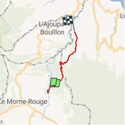
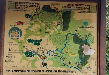
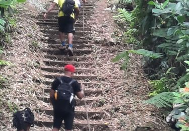
Trail Walking of 9.4 km to be discovered at Martinique, Unknown, Le Morne-Rouge. This trail is proposed by Lamartiniere.

Description

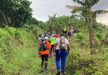
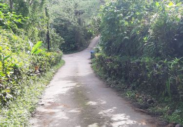
pare le bois Jordan - avec autorisation de passage dans bananeraie bio.

Elevation profile

Positioning

Country:
France
Region :
Martinique
Department/Province :
Unknown
Municipality :
Le Morne-Rouge
Location:
Unknown
Start:(UTM)
702765 ; 1634809 (20P) N.

Comments

Please log in to post a review or rate the element


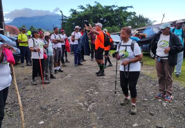
Départ Mac Intosh (D12) Le Morne-Rouge, arrivée Oceanic-club de Morne Capot (D12) Le Lorrain. Magnifique randonnée en forêt hygrophile, dense. Particularité : Après la forêt autorisation de passage obligatoire pour contourner la bananeraie bio La Rougery afin de se diriger vers Le Morne Capot. Localisation trace sur bananeraie problématique suite hautes herbes et trace non utilisée proximité hangar "Kara". fernand Lamartiniere. Possibilité de rencontrer le Delicatissima.


Trails nearby

Trail Walking Le Morne-Rouge - Morne la Caillerie, Trace des Jésuites - Photo
Walking
GUIDE
David25400

Walking

Easy
Le Morne-Rouge, Martinique, Unknown, France
11.2 km | 18.2 km-effort
3h 55min
Yes
Trail Walking Fonds-Saint-Denis - Fonds st Denis  - Photo
Walking
GUIDE
GabyG

Walking

Difficult
Fonds-Saint-Denis, Martinique, Unknown, France
10 km | 15.2 km-effort
3h 11min
Yes
Trail Walking L'Ajoupa-Bouillon - Montagne pelée  - Photo
Walking
GUIDE
Alizée.pee

Walking

Difficult
L'Ajoupa-Bouillon, Martinique, Unknown, France
7.5 km | 16.5 km-effort
6h 2min
Yes
Trail Walking Le Lorrain - Fond capot oceanic fond cani morne Degras - Photo
Walking
GUIDE
manuelPerez

Walking

Le Lorrain, Martinique, Unknown, France
8.5 km | 11.9 km-effort
3h 44min
Yes
Trail Walking Le Lorrain - Mornes Capot / Lorrain Martinique - Photo
Walking
GUIDE
GabyG

Walking

Medium
(1)
Le Lorrain, Martinique, Unknown, France
8.5 km | 11.8 km-effort
3h 41min
Yes
Trail Walking Le Morne-Rouge - Crête du Cournan boucle - Photo
Walking
GUIDE
Lamartiniere

Walking

Medium
Le Morne-Rouge, Martinique, Unknown, France
4.2 km | 8.2 km-effort
2h 15min
Yes
Trail Walking Le Morne-Rouge - Ste Cecile par morne chacun - Photo
Walking
GUIDE
manuelPerez

Walking

Le Morne-Rouge, Martinique, Unknown, France
11.9 km | 18.9 km-effort
4h 55min
Yes
Trail Walking Le Morne-Rouge - Trace des Jésuites  - Photo
Walking
GUIDE
GabyG

Walking

Medium
Le Morne-Rouge, Martinique, Unknown, France
5.2 km | 8.8 km-effort
2h 5min
Yes
Trail Walking Le Lorrain - Fonds Labour - Fonds Duclos 2 - Photo
Walking
GUIDE
Lamartiniere

Walking

Very easy
Le Lorrain, Martinique, Unknown, France
7.7 km | 10.9 km-effort
2h 20min
Yes


Close
My subscriptions